Garibaldi Resources is drilling a nickel copper magmatic sulfide system at its Nickel Mountain project in the Golden Triangle of British Columbia. I've discussed it in a recent blog post. My position has been that so far they haven't drilled any new areas not already known from exploration conducted between the 1960's and 1990. Yes, they have intercepted massive sulfides over significant intervals that exceed the results of historic drilling. This could be for various reasons including poor drilling with lots of core loss in the historical programs. More likely, they have encountered the thicker sequence of mineralization within the historic zones.
Several holes, namely #4, #9 and #14 have intercepted massive sulfide "lenses" which Garibaldi is calling an exciting "discovery". The problem is that it might not be one. As I've been able to determine from compiling historical data, the resource that was calculated for the E&L deposit at Nickel Mountain during the 1960s includes a projection from surface to a depth of over 200 meters in a total of three mineralized zones encountered from outcrop. The main outcrop to the northwest consisting of two connected massive sulfide zones was tested with several drill holes and given an indicated resource classification. The outcrop to the southeast (trenched at surface, drilled with just a single shallow hole, and assumed to have a similar underground extent as the main zone) was classified 50/50 as indicated and inferred resource. All the outcrops, just like the underground mineralization, consist of a disseminated halo around a massive sulfide core.
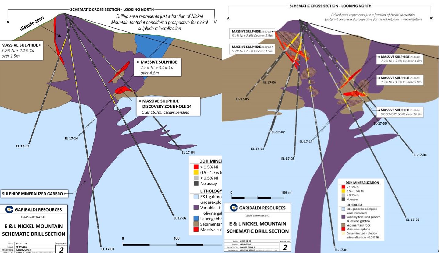
Along comes Garibaldi and on November 20 declares a "discovery zone" based on Hole 14 with visual massive sulfides over 16+ meters. This sounds pretty good, except the description in the press release seems to indicate that the zone is pretty close to the historic outcrops (the hole is collared to the east of the outcrops but drilled back towards the main zone). This is confirmed when Garibaldi releases a drill cross section a few days later after the British Columbia Securities Commission forces management to disclose more information about the drill holes including collar coordinates and orientation. The drill cross section, however, does not show the massive sulfide outcrop at surface in the southeast zone but rather labels it a "leucogabbro/diorite". It's quite obvious to me at this point (whereas it wasn't so clear prior to reviewing this cross section) that the "new discovery zone" corresponds to the historic massive sulfide outcrop in the southeast zone even though it isn't labeled as such on the cross section. The market sells off on the news but not because of the dubious nature of the "discovery", rather because it's so hyped that it has nowhere to go but down.

The above image is courtesy the Angrygeologist, who has combined the original cross section provided by Garibaldi along with the one updated subsequent to the release of assays for holes 5-9 on December 8, 2017. Notice the labeling and presence of a surface outcrop in the image on the right hand side. That appears to be the same location as the historic southeast zone which was already classified as an indicated/inferred resource back in the 1960s. Hole 14 is collared in this zone and is drilled directly down plunge. Still, the "discovery" of massive sulfides seems to be quite positive when looking at only these cross sections. After all, there is no mineralization at surface (red), only some purple colored stuff. So they found an entirely new massive sulfide zone, right?
Yes a true discovery has been made. No, not at Nickel Mountain, but in a presentation to the Vancouver Mining Exploration Group on December 7, 2017. One of the slides is from Garibaldi and it contains the missing drill map that should have accompanied the cross section but has seen no public disclosure to date:

Aha! Much better. Now we can see the surface outcrop of massive sulfides, both the northwest main zone (which is a U shape) as well as the elongated "blob" to the southeast. We can also see where the initial drill holes 1-4 are located, as well as the "discovery" hole 14. And all of a sudden the story doesn't seem as special. They drilled the "discovery" hole right under the outcrop of massive sulfides included as a resource in the 1960s and as shown on a "1970 Sumitomo surface map". Sumitomo optioned the property in order to expand the resource to depth (beyond the 200 meters assumed in the indicated/inferred resource), which they failed to do despite digging an adit and drilling from underground. Their conclusion was that the surface outcrops may extend perhaps a couple hundred meters below surface but probably not much more. And guess where Garibaldi made its "discovery" with hole 14? Right below surface where Sumitomo and prior operators had thought there might be massive sulfides continuing below the outcrop, but they weren't even interested in finding out because that wouldn't be enough to make a mine. They needed to find lateral or depth extensions to the already known zones. Which is exactly where we are today. The grades may be better than thought, and yes grade is king, but tonnage is queen.
I'm not going to ask why Garibaldi hasn't provided the drill map, only the cross section. The answer seems patently obvious. They don't have a "new discovery zone" at all. They have confirmation that the massive sulfides persist at least 100 meters under the outcrops and maybe 200 meters as assumed in the historic resource.
Disclosure: This is not investment advice. Consult your own expert. No position direct or indirect in, nor any relationship with, Garibaldi Resources.
Several holes, namely #4, #9 and #14 have intercepted massive sulfide "lenses" which Garibaldi is calling an exciting "discovery". The problem is that it might not be one. As I've been able to determine from compiling historical data, the resource that was calculated for the E&L deposit at Nickel Mountain during the 1960s includes a projection from surface to a depth of over 200 meters in a total of three mineralized zones encountered from outcrop. The main outcrop to the northwest consisting of two connected massive sulfide zones was tested with several drill holes and given an indicated resource classification. The outcrop to the southeast (trenched at surface, drilled with just a single shallow hole, and assumed to have a similar underground extent as the main zone) was classified 50/50 as indicated and inferred resource. All the outcrops, just like the underground mineralization, consist of a disseminated halo around a massive sulfide core.
Along comes Garibaldi and on November 20 declares a "discovery zone" based on Hole 14 with visual massive sulfides over 16+ meters. This sounds pretty good, except the description in the press release seems to indicate that the zone is pretty close to the historic outcrops (the hole is collared to the east of the outcrops but drilled back towards the main zone). This is confirmed when Garibaldi releases a drill cross section a few days later after the British Columbia Securities Commission forces management to disclose more information about the drill holes including collar coordinates and orientation. The drill cross section, however, does not show the massive sulfide outcrop at surface in the southeast zone but rather labels it a "leucogabbro/diorite". It's quite obvious to me at this point (whereas it wasn't so clear prior to reviewing this cross section) that the "new discovery zone" corresponds to the historic massive sulfide outcrop in the southeast zone even though it isn't labeled as such on the cross section. The market sells off on the news but not because of the dubious nature of the "discovery", rather because it's so hyped that it has nowhere to go but down.
The above image is courtesy the Angrygeologist, who has combined the original cross section provided by Garibaldi along with the one updated subsequent to the release of assays for holes 5-9 on December 8, 2017. Notice the labeling and presence of a surface outcrop in the image on the right hand side. That appears to be the same location as the historic southeast zone which was already classified as an indicated/inferred resource back in the 1960s. Hole 14 is collared in this zone and is drilled directly down plunge. Still, the "discovery" of massive sulfides seems to be quite positive when looking at only these cross sections. After all, there is no mineralization at surface (red), only some purple colored stuff. So they found an entirely new massive sulfide zone, right?
Yes a true discovery has been made. No, not at Nickel Mountain, but in a presentation to the Vancouver Mining Exploration Group on December 7, 2017. One of the slides is from Garibaldi and it contains the missing drill map that should have accompanied the cross section but has seen no public disclosure to date:

Aha! Much better. Now we can see the surface outcrop of massive sulfides, both the northwest main zone (which is a U shape) as well as the elongated "blob" to the southeast. We can also see where the initial drill holes 1-4 are located, as well as the "discovery" hole 14. And all of a sudden the story doesn't seem as special. They drilled the "discovery" hole right under the outcrop of massive sulfides included as a resource in the 1960s and as shown on a "1970 Sumitomo surface map". Sumitomo optioned the property in order to expand the resource to depth (beyond the 200 meters assumed in the indicated/inferred resource), which they failed to do despite digging an adit and drilling from underground. Their conclusion was that the surface outcrops may extend perhaps a couple hundred meters below surface but probably not much more. And guess where Garibaldi made its "discovery" with hole 14? Right below surface where Sumitomo and prior operators had thought there might be massive sulfides continuing below the outcrop, but they weren't even interested in finding out because that wouldn't be enough to make a mine. They needed to find lateral or depth extensions to the already known zones. Which is exactly where we are today. The grades may be better than thought, and yes grade is king, but tonnage is queen.
I'm not going to ask why Garibaldi hasn't provided the drill map, only the cross section. The answer seems patently obvious. They don't have a "new discovery zone" at all. They have confirmation that the massive sulfides persist at least 100 meters under the outcrops and maybe 200 meters as assumed in the historic resource.
Disclosure: This is not investment advice. Consult your own expert. No position direct or indirect in, nor any relationship with, Garibaldi Resources.
Comments
Post a Comment